

Arrival at Tribhuwan International Airport. Our Staff member meets you and transfers you to the hotel.
Overnight at the hotel.
Rolwaling Region

Trek Starting Point
Jagat

Trek Ending Point
Lukla

Departure From
Kathmandu

Transportation
Tourist Coach, Domestic flight

Style
High-altitude Trekking & Climbing

Meal
Breakfast, Lunch, Dinner

Accommodation
Tea house / Tourist standard hotel in Kathmandu
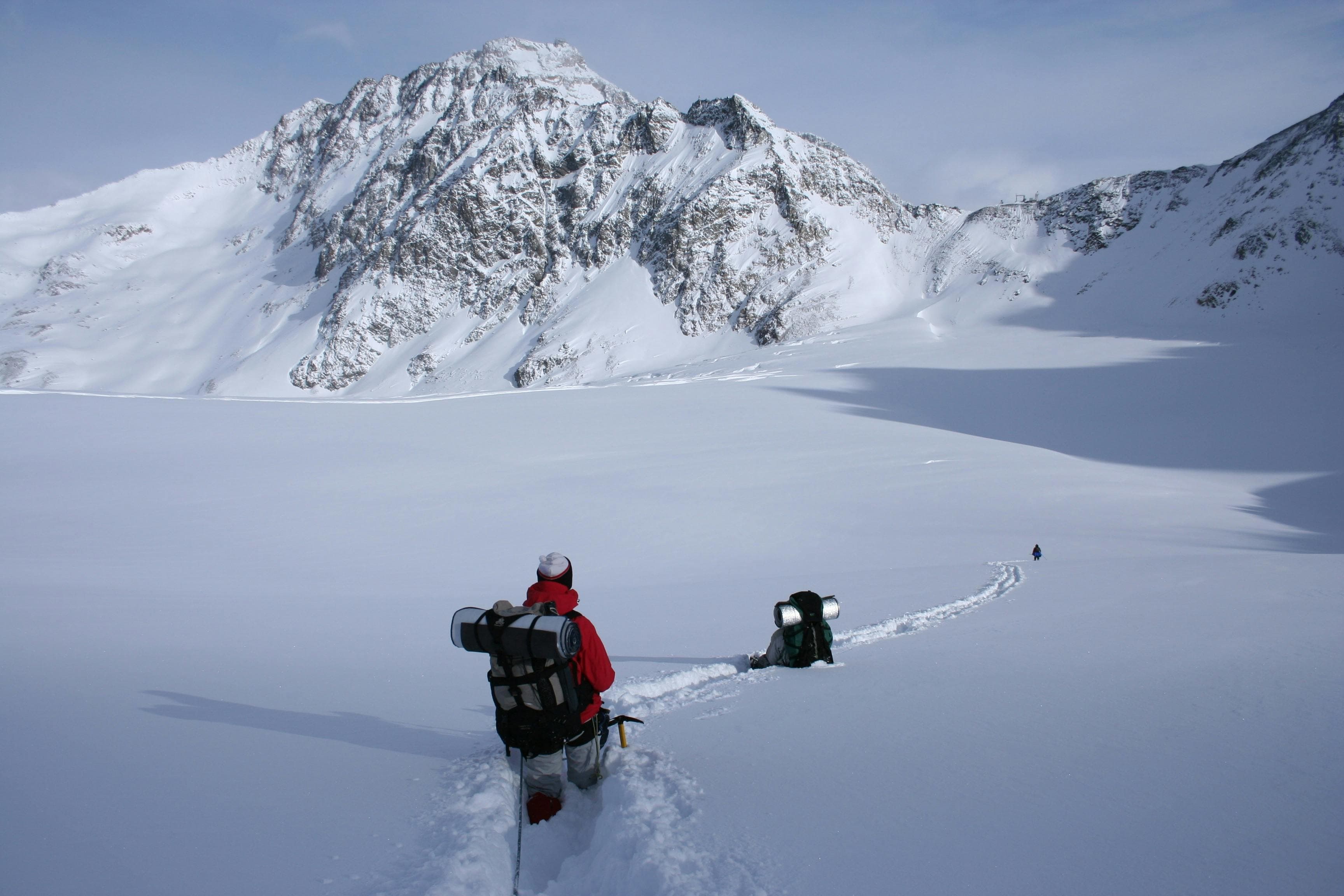
Pharchamo Peak (6,273 m / 20,581 ft) is a striking snow and ice-covered mountain located in the Rolwaling Himalaya of eastern Nepal, forming part of the dramatic alpine landscape between the Rolwaling and Khumbu regions. It is most commonly climbed via the Tashi Lapcha Pass (5,755 m / 18,881 ft), making it a classic expedition peak combined with a high Himalayan crossing.
The peak is considered a technical alpine climb, involving steep snow slopes, glacier travel, and exposed ridge sections. Depending on conditions, climbers may encounter crevasses, fixed rope sections, and sustained high-altitude terrain, requiring solid experience in ice and snow climbing techniques such as crampon use and rope handling.
The standard approach begins from the Rolwaling Valley (Simigaon or Na side), ascending through remote villages, alpine camps, and glacier terrain before reaching high camps beneath the peak. From there, climbers typically attempt the summit via the upper snow slopes, with panoramic views of the Rolwaling Himal, Khumbu peaks, and surrounding Himalayan giants.
Due to its altitude and technical nature, Pharchamo Peak is regarded as a challenging expedition peak rather than a trekking peak, often chosen by climbers seeking a serious but achievable Himalayan objective combined with the Tashi Lapcha crossing.
Overall, Pharchamo Peak offers a rewarding high-altitude experience, combining remote wilderness, technical climbing, and one of the most scenic pass crossings in Nepal.
Arrival at Tribhuwan International Airport. Our Staff member meets you and transfers you to the hotel.
Overnight at the hotel.
After breakfast at the hotel, our guide will meet you for a detailed trip briefing covering the itinerary, route conditions, safety procedures, altitude considerations, and important preparations for the journey ahead. For peak climbing expeditions, the climbing guide will also check the required mountaineering equipment and provide guidance on any necessary gear adjustments before departure.
During the briefing, we will complete the required trekking and climbing formalities, including necessary permits and documentation. Afterward, we will explore some of Kathmandu Valley's cultural highlights, including UNESCO World Heritage Sites such as Boudhanath Stupa, one of the largest Buddhist stupas in the world, and Swayambhunath Stupa, also known as the Monkey Temple.
The rest of the day is free for final preparations, including organizing trekking equipment, purchasing any last-minute essentials, and making final arrangements before heading into the Himalaya. Overnight at the hotel.
Today, we begin our journey with breakfast in Kathmandu before departing for a scenic drive to Jagat (1,150 m) via Dolakha. After an early morning meal, we leave the busy capital behind and gradually enter the peaceful hills and valleys of eastern Nepal. Jagat is a quiet riverside settlement and an important stop along the route toward the Rolwaling region and nearby Himalayan trekking areas.
The drive takes approximately 9 – 11 hours and covers about 240 – 260 km, depending on road and weather conditions.
Leaving Kathmandu, we follow the Arniko Highway eastward before turning north toward Dolakha. The route passes through rolling green hills, terraced farmland, traditional villages, and bustling roadside towns. Along the way, travelers enjoy views of rivers, forested slopes, and distant Himalayan landscapes.
As we continue beyond Dolakha Bazaar, the road becomes narrower and more rugged, winding through remote mountain terrain and alongside deep river gorges. The journey offers dramatic scenery with waterfalls, suspension bridges, rocky cliffs, and occasional glimpses of snow-capped peaks in the distance.
Finally, we arrive at Jagat, a small mountain settlement located along the Tama Koshi River. Surrounded by steep hills and natural beauty, Jagat serves as a gateway toward the Rolwaling Valley and several remote Himalayan trekking routes. Overnight stay at a local guesthouse or teahouse in Jagat.
From Jagat (approx. 1,300 m / 4,265 ft), we begin our ascent along the Rolwaling River toward Simigaon (2,050 m / 6,726 ft), gradually leaving the lower hills and entering the more rugged Rolwaling Valley.
The trek takes approximately 5 – 6 hours and covers around 12 – 14 km (7.5 – 8.7 miles), depending on pace and trail conditions.
The trail initially winds through terraced fields, small villages, and patches of forest. As we ascend, pine, rhododendron, and mixed hardwood forests become denser, and the valley narrows with steep hills rising on both sides. The trail follows the Rolwaling River, crossing small streams and occasional rocky sections that require careful footing.
The scenery gradually changes from cultivated lower hills to more alpine terrain, with towering cliffs and ridges framing the valley. Although the ascent is steady, it is not technically difficult, but the sustained uphill requires moderate endurance.
Finally, we arrive at Simigaon, a peaceful riverside settlement that serves as a gateway to the upper Rolwaling Valley.
Overnight stay at a teahouse or lodge in Simigaon.
From Simigaon (2,050 m / 6,726 ft), we begin our ascent toward Dongang (2,800 m / 9,186 ft), entering the higher alpine zone of the Rolwaling Valley.
The trek takes approximately 4 – 5 hours and covers around 10 – 12 km (6–7.5 miles), depending on trail conditions and pace.
The trail gradually climbs through mixed forests of pine, rhododendron, and hardwoods, with occasional terraced fields and seasonal herding shelters along the way. The path follows the valley, winding along streams and rocky sections.
As we gain altitude, the landscape opens to spectacular views of the surrounding mountains, cliffs, and ridges. The trail becomes steeper in sections, requiring steady footing and moderate effort.
Finally, we arrive at Dongang, a small alpine settlement that serves as a gateway to the higher Rolwaling Valley and a stopover before continuing toward Beding or other high-altitude points.
Overnight stay at a teahouse or lodge in Dongang.
Today, we continue our trek from Dongang (2,800 m / 9,186 ft) to Beding (3,690 m / 12,106 ft), gradually ascending into the higher alpine landscapes of the Rolwaling Valley. Beding is the largest Sherpa settlement in the region and an important acclimatization stop surrounded by dramatic Himalayan scenery.
The trek takes approximately 5 – 6 hours and covers around 9 – 11 km (5.5 – 6.8 miles), depending on trail conditions and walking pace.
After breakfast, the trail follows the Rolwaling River through forests of pine, juniper, and rhododendron before opening into wider alpine terrain. Along the way, we pass waterfalls, yak grazing areas, mani stones, and small seasonal settlements, with increasingly impressive views of the surrounding snow-capped peaks and the Gaurishankar range.
Finally, we arrive at Beding, a traditional Sherpa village known for its monastery, stone houses, and beautiful mountain setting.
Overnight stay at a local teahouse in Beding.
Today is an acclimatization day in Beding, allowing the body to adjust to the higher altitude before continuing further into the Rolwaling Valley. Proper rest and gradual activity help reduce the risk of altitude sickness and ensure a safer ascent ahead.
In the morning, we may take a short hike around Beding or ascend a nearby ridge for better acclimatization. These optional walks offer excellent views of the surrounding peaks, glaciers, and the dramatic Rolwaling Valley, while keeping the body active at altitude. The rest of the day is free to relax, explore the village, and experience the traditional Sherpa lifestyle.
Beding is the largest settlement in the region, known for its ancient monastery, stone-built houses, and strong Buddhist culture. You can spend time interacting with locals or simply enjoy the peaceful mountain environment.
Overnight stay at a local teahouse in Beding.
Today, we trek from Beding to Na (4,183 m / 13,757 ft), ascending deeper into the upper Rolwaling Valley. This short but steady climb allows us to adjust to higher altitude while enjoying spectacular alpine scenery.
The trek takes approximately 3 – 4 hours and covers around 4.5 – 5 km (2.8 – 3.1 miles).
After leaving Beding, the trail winds through open yak pastures, rocky paths, and glacial valleys, with sparse vegetation and panoramic views of surrounding snow-capped peaks. Along the way, we pass seasonal herding shelters and small streams fed by the glaciers above.
We arrive at Na, a remote seasonal settlement set in a vast glacial valley beneath towering Himalayan mountains, serving as a key stop before reaching Tsho Rolpa.
Overnight stay at a local teahouse or lodge in Na.
From Na (4,183 m / 13,757 ft), we begin our trek towards the remote alpine campsite of Chyukyoma (approx. 4,400 m / 14,436 ft) in the upper Rolwaling Valley. This quiet and untouched section of the Himalayas offers a true wilderness trekking experience, surrounded by rugged terrain, glacial formations, and dramatic mountain scenery.
The trek takes approximately 3 – 4 hours and covers around 4.5 – 5.5 km through gradually ascending alpine terrain. The trail climbs steadily through open yak pastures, rocky slopes, and moraine landscapes shaped by ancient glaciers.
As we ascend, the valley opens into wider high-altitude views, with striking panoramas of the surrounding Rolwaling peaks and deep glacial valleys below. The route remains remote and peaceful, making it ideal for acclimatization and immersive Himalayan trekking.
Finally, we arrive at Chyukyoma, a secluded high-altitude campsite set in a wide alpine basin, offering a peaceful overnight stay surrounded by towering Himalayan landscapes. Overnight stay at a tented camp.
Departing Chyukyoma (approx. 4,400 m / 14,436 ft), we continue deeper into the Rolwaling Himalayas towards the edge of the Trakarding Glacier (approx. 4,800 m / 15,748 ft). This section marks a clear transition from alpine trekking terrain into a more rugged glacial environment, surrounded by dramatic ice formations and high Himalayan peaks.
The trek takes approximately 3.5 – 5 hours and covers around 5 – 6 km, depending on glacier approach conditions. The trail becomes more demanding as it crosses rocky moraines, loose scree, and glacial debris, requiring careful footing and steady high-altitude pacing.
As we ascend, the landscape opens into a vast glacial basin with increasingly close views of the surrounding Rolwaling peaks. The terrain becomes more raw and exposed, with visible ice fields and glacier formations marking the approach to one of the key high-altitude zones of the region.
Eventually, we reach the edge of the Trakarding Glacier, a remote and dramatic ice field that serves as a gateway for expeditions moving deeper into the Rolwaling Himalayas. Overnight stay at a tented camp.
Departing the edge of the Trakarding Glacier, we continue the ascent towards Tashi Lapcha Phedi (5,100 m / 16,732 ft), entering a more demanding high-altitude section of the Rolwaling–Khumbu crossing route. This stage takes us fully into glacial terrain, surrounded by vast ice formations and rugged Himalayan landscapes.
The trek takes approximately 3.5 – 5 hours and covers around 4 – 5 km, depending on snow and glacier conditions. The route crosses uneven moraines, icy sections, and loose glacial debris, requiring careful movement and steady high-altitude pacing.
As we ascend, the landscape becomes increasingly remote and exposed, with sweeping views of surrounding peaks and deep glacier valleys. The environment reflects true expedition conditions, where ice, snow, and silence dominate the terrain.
Finally, we arrive at Tashi Lapcha Phedi, a strategically located high camp at the base of the Tashi Lapcha Pass, where we prepare for the next stage of the crossing. Overnight stay at tented camp.
The day begins with a steady ascent from Tashi Lapcha Phedi towards the Tashi Lapcha Pass (5,755 m / 18,881 ft). This section involves high-altitude glacier travel, steep snow slopes, and exposed terrain, requiring careful pacing and the use of rope support in certain sections depending on conditions.
The climb to and across the pass typically takes 5 – 7 hours, with weather and snow conditions playing a major role in timing. From the summit of the pass, expansive views open up across the Rolwaling and Khumbu Himalayan ranges, marking a major highlight of the expedition.
After crossing the Tashi Lapcha Pass, the route continues onto the Khumbu side, descending through glacial terrain and moraine slopes before gradually traversing towards Pharchamo High Camp (approx. 5,600 m / 18,373 ft).
Finally, we reach Pharchamo High Camp, a remote alpine campsite set beneath the upper slopes of Pharchamo Peak, where we establish tented accommodation and rest after a demanding high-altitude crossing.
The summit push begins early from Pharchamo High Camp (Tashi Puk) (approx. 5,600 m / 18,373 ft), heading towards the summit of Pharchamo Peak (6,273 m / 20,581 ft). The climb involves steep snow slopes, glacier travel, and exposed alpine terrain, requiring strong endurance and prior high-altitude acclimatization.
The ascent and descent take approximately 8 – 12 hours, covering around 6 – 8 km round trip, depending on snow conditions and the chosen route line. Fixed rope support and standard alpine techniques are used where necessary to navigate technical and exposed sections safely.
As the elevation increases, the landscape opens into vast Himalayan panoramas, with sweeping views of the Rolwaling and Khumbu ranges, surrounded by glaciers and high alpine peaks.
After reaching the summit of Pharchamo Peak (6,273 m), we take a short moment to celebrate the achievement before carefully descending back to Pharchamo High Camp (Tashi Puk) for rest and recovery. Overnight stay at tented camp.
A contingency day is kept in the itinerary as a safety buffer for the expedition, allowing flexibility in case of unfavorable weather conditions, heavy snowfall, route delays, or acclimatization needs during the high-altitude climb.
This additional day ensures a safer and more successful summit attempt of Pharchamo Peak (6,273 m / 20,581 ft), as conditions in the Rolwaling–Khumbu region can change rapidly. It may be used either at High Camp, Base Camp, or en route, depending on the expedition progress and guide decision.
If the schedule proceeds smoothly without delays, this day can also be used for rest, exploration, or gradual descent, helping the team recover after the summit push and improve overall safety margins.
This flexibility is an important part of responsible Himalayan expedition planning, ensuring both safety and success rate remain the top priority.
After the successful summit of Pharchamo Peak (6,273 m / 20,581 ft) and completion of the expedition, we begin our descent from Pharchamo High Camp (Tashi Puk) (approx. 5,600 m / 18,373 ft) towards the Khumbu Valley via the Tashi Lapcha route. This marks the start of the journey back to lower elevations after the high-altitude climbing phase.
The trek takes approximately 7 – 9 hours and covers around 12 – 15 km, depending on snow and glacier conditions. The initial section crosses glacial terrain and moraine slopes, requiring careful movement before joining more defined trekking trails.
As we descend, the landscape gradually changes from harsh alpine and ice-covered terrain into greener valleys and traditional Himalayan trails. Throughout the journey, we continue to enjoy views of the Rolwaling and Khumbu Himalayan ranges, offering a final glimpse of the high mountains.
Finally, we arrive at Thame (3,820 m / 12,533 ft), a traditional Sherpa village in the Khumbu region, where we rest in a comfortable teahouse and conclude the high-altitude section of the expedition. Overnight stay at a teahouse.
We begin our descent from Thame (3,820 m / 12,533 ft), following a scenic trail through the upper Khumbu region towards Namche Bazaar (3,440 m / 11,286 ft). This is a pleasant trekking day after the high-altitude expedition, offering a gradual return to lower elevations.
The trek takes approximately 4 – 5 hours and covers around 9 – 11 km along well-established Himalayan trails. The route descends through traditional Sherpa villages, stone-built settlements, and pine forest sections, with occasional suspension bridges crossing the Dudh Koshi River.
As we approach Namche, the trail becomes more lively with increased local activity, lodges, and trade movement. Mountain views continue to appear along the way, offering a final glimpse of the surrounding peaks before reaching the bustling hub of the Khumbu region.
Finally, we arrive at Namche Bazaar, where we can relax in a comfortable teahouse and enjoy the vibrant atmosphere of the Himalayas.
Overnight stay at a teahouse in Namche Bazaar.
We begin our final trekking day from Namche Bazaar (3,440 m / 11,286 ft), descending through the scenic Khumbu Valley towards Lukla (2,860 m / 9,383 ft). This marks the final stage of the Himalayan journey.
The trek takes approximately 5 – 6 hours and covers around 16 – 18 km along well-established trails. The route descends through stone steps, suspension bridges, and riverside paths following the Dudh Koshi River, with occasional short uphill sections along the way.
As we descend, the landscape gradually transitions from alpine forests and mountain villages into greener valleys and terraced farmland. The trail passes through settlements such as Monjo, Jorsalle, and Phakding, offering a final glimpse of Sherpa culture and Himalayan life.
Finally, we arrive at Lukla, where the trekking journey concludes. Overnight stay at a lodge.
We conclude the Pharchamo Expedition with a scenic morning flight from Lukla (2,860 m / 9,383 ft) back to Kathmandu (1,400 m / 4,593 ft). This short but spectacular mountain flight offers final aerial views of the Khumbu Himalayas, bringing the journey from high alpine terrain back to the capital.
The flight takes approximately 25 – 35 minutes, depending on weather conditions and air traffic. As we leave the mountains behind, the dramatic landscapes of the Himalayas gradually give way to the green hills and urban valley of Kathmandu.
Upon arrival at Tribhuvan International Airport, the Pharchamo Expedition officially concludes, marking the end of a challenging and rewarding journey through the Rolwaling–Khumbu region. Overnight stay at a hotel.
The final day marks the conclusion of the Pharchamo Expedition. After breakfast in Kathmandu (1,400 m / 4,593 ft), the morning is free for packing, rest, and reflecting on the journey, including the ascent of Pharchamo Peak (6,273 m / 20,581 ft) and crossing of the Tashi Lapcha Pass (5,755 m / 18,881 ft).
At the scheduled time, we transfer you to Tribhuvan International Airport for your onward flight. This final drive through Kathmandu offers a last glimpse of the city before departure.
The expedition officially ends here, with lasting memories of the Rolwaling–Khumbu Himalayas.